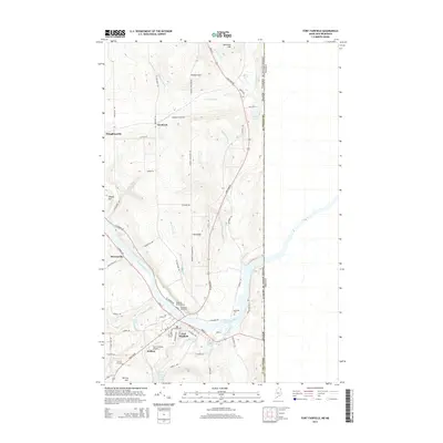
2014 Map of Fort Fairfield
USGS Topo · Published 2014About this map
Fort Fairfield sits prominently along the Aroostook River in this detailed survey of northeastern Maine, where the landscape is defined by its international proximity to the Canada-United States border. The settlement pattern follows the river and high ground, with outlying areas like Stevensville, Houghtonville, and Goodrich connected by a network of rural routes such as W Limestone Rd and N Caribou Rd. The map is particularly valuable for genealogical research, identifying several distinct burial sites including the First Saint Denis Cem, Houghton Burial Ground, and Riverside Cem.
Find a feature on this map
66 named features on this map. Tap any name to fly to it.
Don’t see what you’re looking for? This feature index may not catch every label — zoom into the map to look around manually.
Map Details
Editions of this 2014 Fort Fairfield Map
This is the sole edition of this map. No revisions or reprints were ever made.
Other maps of this area

1930 · Fort Fairfield
USGS Topo · 1:48,000

1933 · Fort Fairfield
USGS Topo · 1:62,500

1936 · Mars Hill
USGS Topo · 1:48,000

1940 · Mars Hill
USGS Topo · 1:62,500

1951 · Mars Hill
USGS Topo · 1:62,500

1951 · Fort Fairfield
USGS Topo · 1:62,500

1953 · Fort Fairfield NW
USGS Topo · 1:24,000
1953 · Limestone
USGS Topo · 1:24,000

1959 · Woodstock
USGS Topo · 1:250,000

1963 · Woodstock
USGS Topo · 1:250,000