
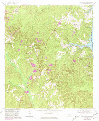
1969 Map of Fort Gaines NW
USGS Topo · Published 1970About this map
Screamer and Scottsboro Crossroads anchor the high ground in this rural stretch of East Alabama during the late 1960s. The landscape is defined by the historical Indian Treaty Boundary which cuts diagonally across the terrain, separating the watersheds of Sandy Creek and Abbie Creek. Along the eastern edge, the rising waters of the Walter F George Res have transformed the riverfront near Otho, while extensive Strip Mines and the Mc Cloud quarry operation near Pleasant Hill reveal the area's mid-century industrial activity. The map is a vital record for genealogists, preserving the locations of numerous country congregations and burial grounds such as New Hope Ch, Old Judson Cem, and Pleasant Grove Ch.
Find a feature on this map
45 named features on this map. Tap any name to fly to it.
Don’t see what you’re looking for? This feature index may not catch every label — zoom into the map to look around manually.
Map Details
Editions of this 1969 Fort Gaines NW Map
2 editions found
Other maps of this area

1953 · Dothan
USGS Topo · 1:250,000

1954 · Dothan
USGS Topo · 1:250,000

1955 · Dothan
USGS Topo · 1:250,000

1967 · Hatcher
USGS Topo · 1:24,000

1968 · Baker Hill
USGS Topo · 1:24,000

1968 · Eufaula South
USGS Topo · 1:24,000

1969 · Abbeville West
USGS Topo · 1:24,000

1969 · Fort Gaines
USGS Topo · 1:24,000

1969 · Fort Gaines NE
USGS Topo · 1:24,000
1969 · Lawrenceville
USGS Topo · 1:24,000