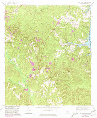
1969 Map of Fort Gaines NW
USGS Topo · Published 1981About this map
The Indian Treaty Boundary cuts a diagonal path through this 1969 survey of the Alabama-Georgia borderlands, marking a landscape defined by small crossroads settlements and creek-side agriculture. Communities like Scottsboro Crossroads and Screamer anchor the upland ridges between the deeply incised valleys of Abbie Creek and Hardridge Creek. The influence of the Chattahoochee River is prominent on the eastern edge, where the Walter F George Res has altered the historic shoreline near Otho. Local history is preserved in the numerous rural congregations and burial grounds, such as Mt Olive Ch and the Free Gift Cem. In the northwest, near Pleasant Hill, the landscape shows the distinct footprint of industrial activity with several active Strip Mines, contrasting with the more traditional land use patterns found further south toward Waitford.
Find a feature on this map
43 named features on this map. Tap any name to fly to it.
Don’t see what you’re looking for? This feature index may not catch every label — zoom into the map to look around manually.
Map Details
Editions of this 1969 Fort Gaines NW Map
2 editions found
Other maps of this area

1953 · Dothan
USGS Topo · 1:250,000

1954 · Dothan
USGS Topo · 1:250,000

1955 · Dothan
USGS Topo · 1:250,000

1967 · Hatcher
USGS Topo · 1:24,000

1968 · Baker Hill
USGS Topo · 1:24,000

1968 · Eufaula South
USGS Topo · 1:24,000

1969 · Abbeville West
USGS Topo · 1:24,000

1969 · Fort Gaines
USGS Topo · 1:24,000

1969 · Fort Gaines NW
USGS Topo · 1:24,000

1969 · Fort Gaines NE
USGS Topo · 1:24,000