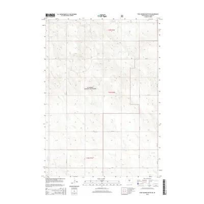
2015 Map of Fort George Butte SW
USGS Topo · Published 2015About this map
Ft. Pierre National Grassland dominates this portion of Lyman County, preserving a vast expanse of mixed-grass prairie that reflects the enduring ranching character of central South Dakota. The drainage patterns of the high plains are clearly delineated by the winding courses of S Br Cedar Cr in the north and the headwaters of Stony Butte Cr and Nail Cr in the south. This 2015 survey illustrates a landscape of sparse human settlement, where the grid of the Public Land Survey System is articulated by rural corridors such as Co Hwy 25, Co Rd 16, and section roads like 228th St. The map provides a precise view of the topography within Townships 107n and 108n, showing the subtle but complex draws and ridges that define this protected grassland environment.
Find a feature on this map
13 named features on this map. Tap any name to fly to it.
Don’t see what you’re looking for? This feature index may not catch every label — zoom into the map to look around manually.
Map Details
Editions of this 2015 Fort George Butte SW Map
This is the sole edition of this map. No revisions or reprints were ever made.
Other maps of this area

1954 · Pierre
USGS Topo · 1:250,000

1955 · Martin
USGS Topo · 1:250,000

1958 · Pierre
USGS Topo · 1:250,000

1958 · Martin
USGS Topo · 1:250,000

1966 · Ft. George Butte SE
USGS Topo · 1:24,000

1967 · Ft. George Butte NW
USGS Topo · 1:24,000

1967 · Ft. George Butte SW
USGS Topo · 1:24,000
1967 · Ft. George Butte
USGS Topo · 1:24,000

1972 · Pierre 3 SE
USGS Topo · 1:24,000

1972 · Vivian
USGS Topo · 1:24,000