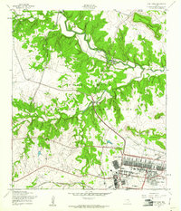
1957 Map of Fort Hood
USGS Topo · Published 1961About this map
The Fort Hood Military Reservation dominates this 1957 landscape, showing the transition from rural Texas terrain into a major military installation. The southeastern corner of the map reveals the developed base infrastructure, featuring residential areas like McNair Village and Chaffee Village, alongside recreational amenities including a Golf Course and Prichard Athletic Field. This development contrasts sharply with the winding watercourses of Corn House Creek and Stampede Creek that cut through the northwestern hills. A significant piece of regional transit history is visible in the Gulf Colorado and Santa Fe (Abandoned) rail line, which suggests the area's earlier connectivity before military expansion. Numerous river crossings, such as Antelope Crossing and Middle Crossing, mark the older trail networks that once served this portion of Coryell and Bell counties.
Find a feature on this map
31 named features on this map. Tap any name to fly to it.
Don’t see what you’re looking for? This feature index may not catch every label — zoom into the map to look around manually.
Map Details
Editions of this 1957 Fort Hood Map
2 editions found
Other maps of this area

1894 · Gatesville
USGS Topo · 1:125,000

1930 · Killeen
USGS Topo · 1:62,500

1947 · Fort Hood
USGS Topo · 1:62,500

1947 · Fort Hood
USGS Topo · 1:24,000

1947 · Purmela
USGS Topo · 1:62,500

1947 · Post Oak Mountain
USGS Topo · 1:24,000

1947 · Killeen
USGS Topo · 1:62,500

1947 · McMillan Mountains
USGS Topo · 1:24,000

1947 · Pidcoke
USGS Topo · 1:24,000

1947 · North Fort Hood
USGS Topo · 1:24,000
Featured Places
- Comanche Village III East, TX
- Chaffee Village, TX
- Comanche Village III West, TX
- Saint Elijah Village, TX
- Patton Park, TX