
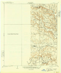
1930 Map of Killeen
USGS Topo · Published 1930About this map
Cowhouse Creek and the Leon River wind through a landscape defined by prominent rises like Owl Creek Mountain and Grimes Mtn. This central Texas survey shows a rural society organized around small communities and local schools, such as Phoenix Sch and Cowan Sch. The settlement of Nolanville serves as a hub on the Santa Fe railroad, while Sparta sits near the head of the Tennessee Valley.
Find a feature on this map
40 named features on this map. Tap any name to fly to it.
Don’t see what you’re looking for? This feature index may not catch every label — zoom into the map to look around manually.
Map Details
Editions of this 1930 Killeen Map
2 editions found
Other maps of this area

1885 · Taylor
USGS Topo · 1:125,000

1887 · Taylor
USGS Topo · 1:125,000

1892 · Temple
USGS Topo · 1:125,000

1893 · Georgetown
USGS Topo · 1:125,000

1894 · Gatesville
USGS Topo · 1:125,000

1894 · Taylor
USGS Topo · 1:125,000

1924 · Gatesville 4-d
USGS Topo · 1:48,000

1924 · Gatesville 4-a
USGS Topo · 1:48,000

1924 · Temple 2-C
USGS Topo · 1:48,000

1924 · Temple 3-C
USGS Topo · 1:48,000