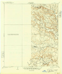
1930 Map of Killeen
USGS Topo · Published 1949About this map
Cowhouse Creek and the Leon River wind through this central Texas landscape, which is marked by a high density of rural schoolhouses and country churches from the early 20th century. The settlement of Nolansville serves as a local hub along the Gulf Colorado and Santa Fe railroad, where Stone Siding indicates the area's logistical connections. Farther south, the Lampasas River flows past Youngsport, framing a terrain defined by Dog Ridge and the Owl Creek Mountain range.
Find a feature on this map
49 named features on this map. Tap any name to fly to it.
Don’t see what you’re looking for? This feature index may not catch every label — zoom into the map to look around manually.
Map Details
Editions of this 1930 Killeen Map
2 editions found

Other maps of this area

1885 · Taylor
USGS Topo · 1:125,000

1887 · Taylor
USGS Topo · 1:125,000

1892 · Temple
USGS Topo · 1:125,000

1893 · Georgetown
USGS Topo · 1:125,000

1894 · Gatesville
USGS Topo · 1:125,000

1894 · Taylor
USGS Topo · 1:125,000

1924 · Gatesville 4-d
USGS Topo · 1:48,000

1924 · Gatesville 4-a
USGS Topo · 1:48,000

1924 · Temple 2-C
USGS Topo · 1:48,000

1924 · Temple 3-C
USGS Topo · 1:48,000