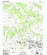
1995 Map of Fort Hood
USGS Topo · Published 1995About this map
The Fort Hood Military Reservation dominates this landscape on the border of Coryell and Bell counties, revealing the extensive infrastructure of one of the nation's premier armored training installations during the mid-1990s. The map illustrates a developed garrison area featuring distinct residential clusters such as Comanche Village I, McNair Village, and Chaffee Village, supported by local institutions like Duncan Sch and Clarke Sch. Beyond the built-up cantonment, the terrain is defined by tactical geography, with numerous firing ranges and strategic high points like Jack Mountain and the Blackwell Mountains. A notable technological detail is the presence of a Monorail line winding through the reservation hills. Waterways including Cowhouse Creek and House Creek segment the training grounds, crossed at named points such as House Crossing and Middle Crossing, which provided essential movement corridors for military maneuvers across the Texas brushland.
Find a feature on this map
46 named features on this map. Tap any name to fly to it.
Don’t see what you’re looking for? This feature index may not catch every label — zoom into the map to look around manually.
Map Details
Editions of this 1995 Fort Hood Map
This is the sole edition of this map. No revisions or reprints were ever made.
Other maps of this area

1894 · Gatesville
USGS Topo · 1:125,000

1930 · Killeen
USGS Topo · 1:62,500

1947 · Fort Hood
USGS Topo · 1:62,500

1947 · Fort Hood
USGS Topo · 1:24,000

1947 · Purmela
USGS Topo · 1:62,500

1947 · Post Oak Mountain
USGS Topo · 1:24,000

1947 · Killeen
USGS Topo · 1:62,500

1947 · McMillan Mountains
USGS Topo · 1:24,000

1947 · Pidcoke
USGS Topo · 1:24,000

1947 · North Fort Hood
USGS Topo · 1:24,000
Featured Places
- Comanche Village III East, TX
- Chaffee Village, TX
- Comanche Village III West, TX
- Saint Elijah Village, TX
- Patton Park, TX