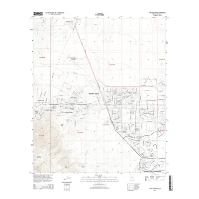
2014 Map of Fort Huachuca
USGS Topo · Published 2014About this map
Sierra Vista and its surrounding neighborhoods anchor this 2014 survey, illustrating the deep integration of military and civilian development in the desert landscape of southern Arizona. The map details the expansive Sierra Vista Municipal Airport-Libby Army Airfield and numerous planned residential areas including Gatewood Housing, De Anza Village, and Apache Flats. The transition from the dense urban grid of Fry to the high-elevation terrain of the Huachuca Mountains is clearly visible, with landmarks such as Garden Ridge and Rock Spring Canyon marking the western ascent.
Find a feature on this map
234 named features on this map. Tap any name to fly to it.
Don’t see what you’re looking for? This feature index may not catch every label — zoom into the map to look around manually.
Map Details
Editions of this 2014 Fort Huachuca Map
This is the sole edition of this map. No revisions or reprints were ever made.
Other maps of this area

1914 · Hereford
USGS Topo · 1:125,000

1915 · Benson
USGS Topo · 1:125,000

1922 · Sunnyside
USGS Topo · 1:62,500

1932 · Stark
USGS Topo · 1:62,500

1932 · Fairbank
USGS Topo · 1:62,500

1938 · Huachuca
USGS Topo · 1:62,500

1938 · Sunnyside
USGS Topo · 1:62,500

1943 · Benson
USGS Topo · 1:125,000

1948 · Huachuca Peak
USGS Topo · 1:24,000

1948 · Fort Huachuca NE
USGS Topo · 1:24,000
Featured Places
- Sierra Vista, AZ
- Huachuca City, AZ
- West Pershing Plaza, Sierra Vista
- Village Meadows, Sierra Vista
- Apache Flats, Sierra Vista