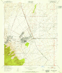
1948 Map of Fort Huachuca
USGS Topo · Published 1953About this map
Fort Huachuca is the central focus of this 1948 survey, shown during its post-war transition. The map captures the dense organization of the main post, including the Hospital and nearby Fort Huachuca Airport, surrounded by the extensive Fort Huachuca Military Reservation. Beyond the gates, the landscape reflects the desert military life of the era, from the Artillery Range and Target Range to the housing at Apache Flats.
Find a feature on this map
28 named features on this map. Tap any name to fly to it.
Don’t see what you’re looking for? This feature index may not catch every label — zoom into the map to look around manually.
Map Details
Editions of this 1948 Fort Huachuca Map
This is the sole edition of this map. No revisions or reprints were ever made.
Other maps of this area

1914 · Hereford
USGS Topo · 1:125,000

1915 · Benson
USGS Topo · 1:125,000

1922 · Sunnyside
USGS Topo · 1:62,500

1932 · Stark
USGS Topo · 1:62,500

1932 · Fairbank
USGS Topo · 1:62,500

1938 · Huachuca
USGS Topo · 1:62,500

1938 · Sunnyside
USGS Topo · 1:62,500

1943 · Benson
USGS Topo · 1:125,000

1948 · Huachuca Peak
USGS Topo · 1:24,000

1948 · Fort Huachuca NE
USGS Topo · 1:24,000
Featured Places
- Sierra Vista, AZ
- Huachuca City, AZ
- Fry, Sierra Vista
- Village Meadows, Sierra Vista
- Gatewood Housing, Sierra Vista