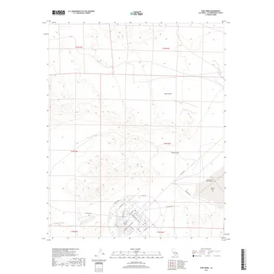
2018 Map of Fort Irwin
USGS Topo · Published 2018About this map
Fort Irwin serves as the focal point for this high-desert landscape in San Bernardino County, where the military footprint and the natural arid environment converge. The base's infrastructure is prominently displayed, featuring the extensive street grid with names like Normandy Dr, Bastogne St, and Alvord Dr. Significant landmarks include the Bicycle Lake Army Airfield, situated adjacent to the dry bed of Bicycle Lake, illustrating the strategic use of flat desert basins for aviation. The terrain is defined by the stark features of the Mojave Desert, where the elevation changes lead into Coyote Canyon. A dense network of perimeter and access roads such as Goldstone Rd and Outer Loop Rd outlines the transition from the concentrated residential and administrative areas of the fort to the expansive training grounds and natural washes.
Find a feature on this map
37 named features on this map. Tap any name to fly to it.
Don’t see what you’re looking for? This feature index may not catch every label — zoom into the map to look around manually.
Map Details
Editions of this 2018 Fort Irwin Map
This is the sole edition of this map. No revisions or reprints were ever made.
Other maps of this area

1933 · Avawatz Mountains
USGS Topo · 1:250,000

1947 · Trona
USGS Topo · 1:250,000

1948 · Trona
USGS Topo · 1:250,000

1948 · Alvord Mountain
USGS Topo · 1:62,500

1948 · Lane Mountain
USGS Topo · 1:62,500

1948 · Goldstone Lake
USGS Topo · 1:62,500

1948 · Tiefort Mountains
USGS Topo · 1:62,500

1951 · Goldstone Lake
USGS Topo · 1:62,500

1951 · Tiefort Mountains
USGS Topo · 1:62,500

1951 · Alvord Mountain
USGS Topo · 1:62,500