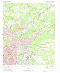
1972 Map of Fort Jackson North
USGS Topo · Published 1974About this map
Fort Jackson Military Reservation occupies the southeastern portion of this map, showcasing the intensive military infrastructure of the early 1970s. This landscape is defined by its complex water systems, where Jackson Creek and Gills Creek feed into numerous reservoirs such as Windsor Lake, Carys Lakes, and Forest Lake. The urban and suburban expansion of Columbia is evident in the sprawling residential areas of Dentsville and Forest Acres, which are intersected by the Southern and Seaboard Coast Line railroads. The area's social history is recorded through numerous institutional landmarks, including the Crafts-Farrow State Hospital, the Carolina Childrens Home, and the Manning Correctional Inst. Recreational and spiritual spaces serve these growing communities, from Sesquicentennial State Park to neighborhood anchors like Covenant Church and the Satchel Ford Road School.
Find a feature on this map
107 named features on this map. Tap any name to fly to it.
Don’t see what you’re looking for? This feature index may not catch every label — zoom into the map to look around manually.
Map Details
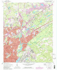
Editions of this 1972 Fort Jackson North Map
2 editions found
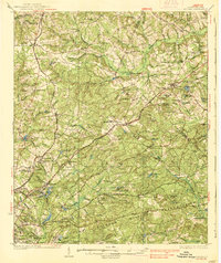
Other maps of this area

1904 · Columbia
USGS Topo · 1:125,000

1935 · Killian
USGS Topo · 1:48,000
1937 · Killian
USGS Topo · 1:62,500

1941 · Spartanburg
USGS Topo · 1:250,000

1942 · Camden
USGS Topo · 1:125,000

1944 · Edmund
USGS Topo · 1:62,500

1947 · Columbia North
USGS Topo · 1:24,000

1948 · Hopkins
USGS Topo · 1:62,500

1948 · Columbia North
USGS Topo · 1:24,000

1949 · Irmo NE
USGS Topo · 1:24,000