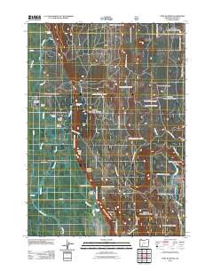
2011 Map of Fort Klamath
USGS Topo · Published 2011About this map
The settlement of Fort Klamath occupies a landscape defined by an intricate network of springs and man-made water systems in Southern Oregon. The 2011 survey reveals the town's enduring layout, featuring the Fort Klamath Post Office and the nearby Fort Klamath Cemetery. A sophisticated system of irrigation and resource management is evident through features like the Wood River Canal, Fort Creek Ditch, and the A Canal, which supported the agricultural needs of the valley. Natural water sources are abundant, from the Wood River Springs in the north to the Tecumseh Spring and the Klamath State Fish Hatchery further south. The topography is anchored by prominent rises such as Sugar Hill and Agency Hill, while the Williamson River and Spring Creek flow through the eastern edge of the quadrangle. This map documents the intersection of natural hydrology and historic human settlement patterns.
Find a feature on this map
30 named features on this map. Tap any name to fly to it.
Don’t see what you’re looking for? This feature index may not catch every label — zoom into the map to look around manually.
Map Details
Editions of this 2011 Fort Klamath Map
This is the sole edition of this map. No revisions or reprints were ever made.
Other maps of this area

1889 · Klamath
USGS Topo · 1:250,000

1891 · Ashland
USGS Topo · 1:250,000

1893 · Ashland
USGS Topo · 1:250,000

1894 · Klamath
USGS Topo · 1:250,000

1897 · Ashland
USGS Topo · 1:250,000

1955 · Pelican Butte
USGS Topo · 1:62,500

1955 · Klamath Falls
USGS Topo · 1:250,000

1955 · Medford
USGS Topo · 1:250,000

1957 · Medford
USGS Topo · 1:250,000

1957 · Chiloquin
USGS Topo · 1:62,500