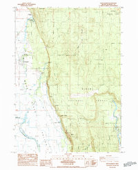
1985 Map of Fort Klamath
USGS Topo · Published 1985About this map
Fort Klamath and the surrounding Wood River Valley are defined by a landscape of abundant water and complex historical borders. This 1980s-era survey documents the remnants of the region's military and tribal history, clearly marking the Old Indian Reservation Boundary and the Old Military Road. The map provides specific locations for the Fort Klamath (Site) and an adjacent Cemetery, along with a Historical Monument. The valley's hydrology is prominent, from the headwaters at Wood River Springs to the Klamath State Fish Hatchery and numerous artesian features like Tecumseh Spring. Significant public lands including Winema National Forest, Jackson F Kimball State Park, and Collier Memorial State Park illustrate the transition from the historic military frontier to a protected natural landscape at the edge of Sun Mountain and Sugar Hill.
Find a feature on this map
30 named features on this map. Tap any name to fly to it.
Don’t see what you’re looking for? This feature index may not catch every label — zoom into the map to look around manually.
Map Details
Editions of this 1985 Fort Klamath Map
This is the sole edition of this map. No revisions or reprints were ever made.
Other maps of this area

1889 · Klamath
USGS Topo · 1:250,000

1891 · Ashland
USGS Topo · 1:250,000

1893 · Ashland
USGS Topo · 1:250,000

1894 · Klamath
USGS Topo · 1:250,000

1897 · Ashland
USGS Topo · 1:250,000

1955 · Pelican Butte
USGS Topo · 1:62,500

1955 · Klamath Falls
USGS Topo · 1:250,000

1955 · Medford
USGS Topo · 1:250,000

1957 · Medford
USGS Topo · 1:250,000

1957 · Chiloquin
USGS Topo · 1:62,500