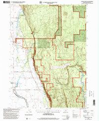
1998 Map of Fort Klamath
USGS Topo · Published 2000About this map
Fort Klamath (Site) anchors this late-twentieth-century study of the Klamath Valley, marking the location of the frontier-era military post near a Historical Monument and a local Cem. The landscape is a complex intersection of hydrology and managed timberlands, where the Winema National Forest meets the valley floor's irrigation network of the North Levee, North Ditch, and various Siphons.
Find a feature on this map
44 named features on this map. Tap any name to fly to it.
Don’t see what you’re looking for? This feature index may not catch every label — zoom into the map to look around manually.
Map Details
Editions of this 1998 Fort Klamath Map
This is the sole edition of this map. No revisions or reprints were ever made.
Other maps of this area

1889 · Klamath
USGS Topo · 1:250,000

1891 · Ashland
USGS Topo · 1:250,000

1893 · Ashland
USGS Topo · 1:250,000

1894 · Klamath
USGS Topo · 1:250,000

1897 · Ashland
USGS Topo · 1:250,000

1955 · Pelican Butte
USGS Topo · 1:62,500

1955 · Klamath Falls
USGS Topo · 1:250,000

1955 · Medford
USGS Topo · 1:250,000

1957 · Medford
USGS Topo · 1:250,000

1957 · Chiloquin
USGS Topo · 1:62,500