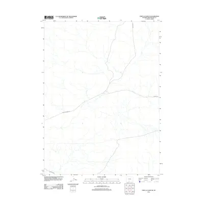
2012 Map of Fort La Clede NE
USGS Topo · Published 2012About this map
The Overland Emigrant Rd cuts a significant path through this part of Sweetwater County, tracing the historic movement of travelers across the Wyoming landscape. This 2012 survey illustrates how modern infrastructure, such as BLM Road 4410 and BLM Road 4411, interacts with the established emigrant trails. The terrain is defined by a complex network of ephemeral drainages that shape the arid environment south of the Red Desert. For researchers, the map provides precise documentation of remote access points like BLM Road 4409, which are essential for navigating this high-plains region. The sparse distribution of named features highlights the open, unsettled nature of this territory, where historic transportation routes remain the primary landmarks of human activity.
Find a feature on this map
4 named features on this map. Tap any name to fly to it.
Don’t see what you’re looking for? This feature index may not catch every label — zoom into the map to look around manually.
Map Details
Editions of this 2012 Fort La Clede NE Map
This is the sole edition of this map. No revisions or reprints were ever made.
Other maps of this area

1954 · Rock Springs
USGS Topo · 1:250,000

1958 · Rock Springs
USGS Topo · 1:250,000

1962 · Rock Springs
USGS Topo · 1:250,000

1970 · Red Desert SW
USGS Topo · 1:24,000
1970 · Kinney Spring
USGS Topo · 1:24,000

1970 · Table Rock
USGS Topo · 1:24,000

1970 · Manuel Gap
USGS Topo · 1:24,000
1970 · Barrel Springs SW
USGS Topo · 1:24,000

1970 · J O Dugway
USGS Topo · 1:24,000

1970 · Fort La Clede NE
USGS Topo · 1:24,000