
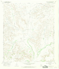
1967 Map of Fort Lancaster
USGS Topo · Published 1970About this map
Fort Lancaster (Ruins) sits near the confluence of Live Oak Creek and the Pecos River, marking a site of significant military history in West Texas. This 1960s survey documents the intersection of natural landmarks and mid-century industrial development, with numerous Oil Wells and a Pumping Sta scattered across the high ground of Field and Cox Hill. The landscape is defined by a dense network of drainages, including Hog Canyon, Musk Canyon, and Mailbox Draw, which carve through the limestone plateaus. Evidence of ranching and travelers' infrastructure appears through features like the Divide Windmill and a Roadside Park situated along the highway. The boundary between Crockett County and Terrell County follows the winding path of the river, anchoring the map's southern edge amidst the complex terrain of Scott Canyon and Loftin Canyon.
Find a feature on this map
19 named features on this map. Tap any name to fly to it.
Don’t see what you’re looking for? This feature index may not catch every label — zoom into the map to look around manually.
Map Details
Editions of this 1967 Fort Lancaster Map
This is the sole edition of this map. No revisions or reprints were ever made.
Other maps of this area

1929 · Sheffield
USGS Topo · 1:125,000

1954 · Sonora
USGS Topo · 1:250,000

1958 · Sonora
USGS Topo · 1:250,000

1967 · Owens Creek SE
USGS Topo · 1:24,000

1967 · Burnt Canyon
USGS Topo · 1:24,000

1967 · Deer Canyon
USGS Topo · 1:24,000

1967 · Bachelor Hill
USGS Topo · 1:24,000

1967 · Sheffield SE
USGS Topo · 1:24,000

1967 · Dead Man Canyon
USGS Topo · 1:24,000
1967 · Owens Creek SW
USGS Topo · 1:24,000