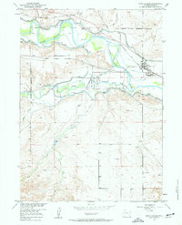
1950 Map of Fort Laramie
USGS Topo · Published 1963About this map
The confluence of the North Platte River and the Laramie River serves as the focal point for this mid-century topographic record, where the transition from frontier military post to preserved history is clearly visible. The boundaries of the Fort Laramie National Monument encompass the heart of the site, while the vast perimeter of the Fort Laramie Military Reservation (Abandoned) stretches across the surrounding plains, marking the former scale of this western outpost.
Find a feature on this map
19 named features on this map. Tap any name to fly to it.
Don’t see what you’re looking for? This feature index may not catch every label — zoom into the map to look around manually.
Map Details
Editions of this 1950 Fort Laramie Map
3 editions found
Other maps of this area

1896 · Patrick
USGS Topo · 1:125,000

1896 · Hartville
USGS Topo · 1:125,000

1901 · Hartville
USGS Topo · 1:125,000

1950 · Rockeagle
USGS Topo · 1:24,000

1950 · Guernsey
USGS Topo · 1:24,000

1950 · Casebier Hill
USGS Topo · 1:24,000

1950 · Fort Laramie
USGS Topo · 1:24,000

1950 · Register Cliff
USGS Topo · 1:24,000

1951 · Eagles Nest
USGS Topo · 1:24,000

1952 · Register Cliff
USGS Topo · 1:24,000