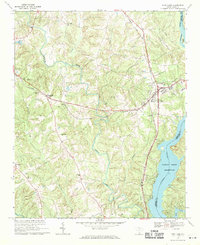
1969 Map of Fort Lawn
USGS Topo · Published 1971About this map
Fort Lawn and the neighboring settlement of Bascomville serve as the primary hubs in this late 1960s survey of the Catawba River valley. The landscape is defined by its industrial and spiritual markers, with the intersection of the Seaboard Coast Line and the Lancaster and Chester railroads facilitating local commerce. Religious life is deeply rooted throughout the countryside, evidenced by numerous rural sanctuaries such as Mt Vernon Ch, Cedar Shoals Ch, and Love-Charity Ch.
Find a feature on this map
31 named features on this map. Tap any name to fly to it.
Don’t see what you’re looking for? This feature index may not catch every label — zoom into the map to look around manually.
Map Details
Editions of this 1969 Fort Lawn Map
This is the sole edition of this map. No revisions or reprints were ever made.
Other maps of this area

1941 · Spartanburg
USGS Topo · 1:250,000

1949 · Rock Hill
USGS Topo · 1:62,500

1953 · Spartanburg
USGS Topo · 1:250,000

1960 · Spartanburg
USGS Topo · 1:250,000

1963 · Spartanburg
USGS Topo · 1:250,000

1964 · Spartanburg
USGS Topo · 1:250,000

1968 · Van Wyck
USGS Topo · 1:24,000

1968 · Catawba
USGS Topo · 1:24,000

1968 · Lancaster SE
USGS Topo · 1:24,000
1969 · Lancaster
USGS Topo · 1:24,000