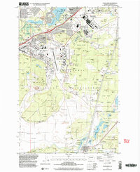
1997 Map of Fort Lewis
USGS Topo · Published 2003About this map
Fort Lewis Military Reservation dominates the landscape south of Tacoma in the late 1990s, revealing the dense infrastructure of one of the nation's premier army installations. The map provides a detailed look at the specialized facilities of the era, from the massive Madigan Army Medical Center and the Mount Rainier Ordnance Depot to the runways of Gray Army Air Field and the adjacent Mc Chord Air Force Base.
Find a feature on this map
139 named features on this map. Tap any name to fly to it.
Don’t see what you’re looking for? This feature index may not catch every label — zoom into the map to look around manually.
Map Details
Editions of this 1997 Fort Lewis Map
This is the sole edition of this map. No revisions or reprints were ever made.
Other maps of this area

1897 · Tacoma
USGS Topo · 1:125,000

1900 · Tacoma
USGS Topo · 1:125,000

1916 · Chehalis
USGS Topo · 1:125,000

1937 · Eatonville
USGS Topo · 1:125,000

1940 · Anderson Island
USGS Topo · 1:62,500

1941 · Tanwax Lake
USGS Topo · 1:62,500

1941 · Tacoma South
USGS Topo · 1:62,500

1944 · Tacoma South
USGS Topo · 1:62,500

1944 · Yelm
USGS Topo · 1:62,500

1944 · Ohop Valley
USGS Topo · 1:62,500