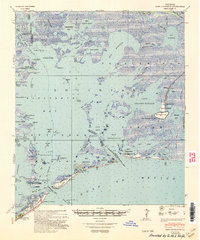
1948 Map of Fort Livingston
USGS Topo · Published 1950About this map
Ft Livingston stands at the strategic entrance of Barataria Pass, anchoring a coastal landscape of barrier islands and extensive wetlands at the edge of the Gulf of Mexico. This postwar era survey documents a transitional maritime economy where traditional settlements like Manila and the Cabanash P O coexist with burgeoning industrial activity. The emergence of the Queen Bess I Oil Field and the Lake Washington Oil Field, alongside a significant Sulphur Mining Area near Grande Ecaille, signals the shift toward offshore resource extraction. The southern edge is defined by Grand Isle, featuring the Grand Isle Airport and the Barataria Lighthouse. This complex network of water bodies, including Lake Grande Ecaille and Batiste Bay, is navigable through numerous passes and bayous like Quatre Bayoux Pass and Bayou Rigaud.
Find a feature on this map
58 named features on this map. Tap any name to fly to it.
Don’t see what you’re looking for? This feature index may not catch every label — zoom into the map to look around manually.
Map Details
Editions of this 1948 Fort Livingston Map
This is the sole edition of this map. No revisions or reprints were ever made.
Other maps of this area

1891 · Pointe a La Hache
USGS Topo · 1:62,500

1892 · Barataria
USGS Topo · 1:62,500

1892 · Cheniere Caminada
USGS Topo · 1:62,500

1892 · Quarantine
USGS Topo · 1:62,500

1892 · Creole
USGS Topo · 1:62,500

1892 · Pointe a La Hache
USGS Topo · 1:62,500

1893 · Fort Livingston
USGS Topo · 1:62,500

1893 · Dime
USGS Topo · 1:62,500

1935 · Port Sulphur
USGS Topo · 1:31,680

1935 · Bastian Bay
USGS Topo · 1:31,680