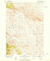
1953 Map of Fort Meade SE
USGS Topo · Published 1955About this map
Pleasant Valley Creek winds through this Meade County landscape, providing a central drainage for a series of small, rural institutions. The 1953 field check documents a community in transition, most notably marking the Harlow Sch (Abandoned) alongside its active replacement, the second Harlow Sch. These small schools and the Pleasant Valley Ch suggest a sparse, ranch-oriented settlement pattern characteristic of the Black Hills fringes. The drainage of Morris Creek to the south supports the Morris Creek Sch, while Antelope Creek cuts through the eastern sections of the quadrangle. For genealogists and local historians, these specific school locations and church labels help pinpoint the center of gravity for families living in the valley before rural school consolidation moved students toward larger towns.
Find a feature on this map
7 named features on this map. Tap any name to fly to it.
Don’t see what you’re looking for? This feature index may not catch every label — zoom into the map to look around manually.
Map Details
Editions of this 1953 Fort Meade SE Map
2 editions found
Other maps of this area

1893 · Rapid
USGS Topo · 1:125,000

1898 · Rapid
USGS Topo · 1:125,000

1903 · Rapid
USGS Topo · 1:125,000

1953 · Rapid City 1 SW
USGS Topo · 1:24,000

1953 · Rapid City 1 NW
USGS Topo · 1:24,000

1953 · Blackhawk
USGS Topo · 1:24,000

1953 · Piedmont
USGS Topo · 1:24,000
1953 · Fort Meade
USGS Topo · 1:24,000

1953 · Rapid City NW
USGS Topo · 1:24,000
1953 · Tilford
USGS Topo · 1:24,000