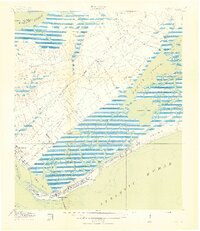
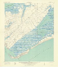
1919 Map of Fort Moultrie
USGS Topo · Published 1919About this map
Fort Moultrie and the tactical landscape of the South Carolina coast dominate this 1918 survey, which was conducted in cooperation with the War Department. The map documents the intricate barrier island geography from Sullivans Island to Isle of Palms, detailing the military presence at the U.S. Rifle Range and the historic Fort Sumter at the edge of the Hog Island Channel. Inland, the rural character of Charleston County is preserved through its early 20th-century educational and religious landmarks, including Long Point School, Fourmile School, and Christ Church. The transition from the established settlement at Mt Pleasant to the salt marshes of Hamlin Sound is marked by the winding paths of Hobcaw Creek and Shem Creek, illustrating a maritime economy reliant on tidal reaches like Seven Reaches and Goat Island Reach before the era of intensive coastal development.
Find a feature on this map
45 named features on this map. Tap any name to fly to it.
Don’t see what you’re looking for? This feature index may not catch every label — zoom into the map to look around manually.
Map Details
Editions of this 1919 Fort Moultrie Map
3 editions found
Other maps of this area

1919 · The Jetties
USGS Topo · 1:21,120

1919 · Capers Island
USGS Topo · 1:21,120

1919 · Wando
USGS Topo · 1:21,120

1919 · Melgrove
USGS Topo · 1:21,120

1919 · Charleston
USGS Topo · 1:21,120

1919 · James Island
USGS Topo · 1:21,120

1919 · Fort Moultrie
USGS Topo · 1:21,120

1919 · Sewee Bay
USGS Topo · 1:21,120

1940 · Melgrove
USGS Topo · 1:24,000

1943 · Capers Island
USGS Topo · 1:24,000