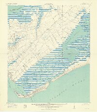
1919 Map of Fort Moultrie
USGS Topo · Published 1936About this map
Fort Moultrie and the historic defenses of Charleston Harbor anchor this coastal survey, which captures the barrier islands and maritime lowcountry at the end of the Great War. On the southern tip of Sullivan Island, the community of Moultrieville and the Atlanticville PO sit adjacent to Fort Sumter, while the U S Rifle Range occupies the land to the north near Mt Pleasant.
Find a feature on this map
46 named features on this map. Tap any name to fly to it.
Don’t see what you’re looking for? This feature index may not catch every label — zoom into the map to look around manually.
Map Details
Editions of this 1919 Fort Moultrie Map
3 editions found
Other maps of this area

1919 · The Jetties
USGS Topo · 1:21,120

1919 · Capers Island
USGS Topo · 1:21,120

1919 · Wando
USGS Topo · 1:21,120

1919 · Melgrove
USGS Topo · 1:21,120

1919 · Charleston
USGS Topo · 1:21,120

1919 · James Island
USGS Topo · 1:21,120

1919 · Fort Moultrie
USGS Topo · 1:21,120

1919 · Sewee Bay
USGS Topo · 1:21,120

1940 · Melgrove
USGS Topo · 1:24,000

1943 · Capers Island
USGS Topo · 1:24,000