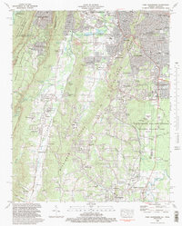
1982 Map of Fort Oglethorpe
USGS Topo · Published 1988About this map
Chickamauga and Chattanooga National Military Park dominates the southeastern quadrant of this study, preserving the complex topography of the 1863 battlefields. The map documents the relationship between the rising elevations of Missionary Ridge and the broad flats of Dry Valley, punctuated by historic sites like Snodgrass Hill and monuments such as the Wilder Obsv Tower. Northward, the industrial and residential growth of Rossville and Fort Oglethorpe reflects the post-war expansion of the Chattanooga metropolitan area across the Tennessee-Georgia state line.
Find a feature on this map
116 named features on this map. Tap any name to fly to it.
Don’t see what you’re looking for? This feature index may not catch every label — zoom into the map to look around manually.
Map Details
Editions of this 1982 Fort Oglethorpe Map
3 editions found
Other maps of this area

1886 · Ringgold
USGS Topo · 1:125,000

1888 · Chattanooga
USGS Topo · 1:125,000

1892 · Ringgold
USGS Topo · 1:125,000

1893 · Chattanooga
USGS Topo · 1:125,000

1935 · East Chattanooga
USGS Topo · 1:24,000

1935 · East Ridge
USGS Topo · 1:24,000

1935 · Durham
USGS Topo · 1:24,000

1935 · Nickajack Gap
USGS Topo · 1:24,000

1936 · Kensington
USGS Topo · 1:24,000

1936 · Hooker
USGS Topo · 1:24,000