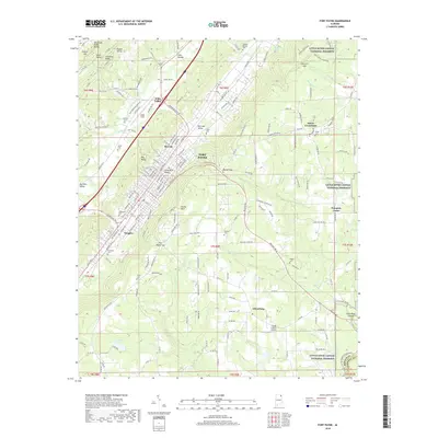
2018 Map of Fort Payne
USGS Topo · Published 2018About this map
Shinbone Ridge and Big Ridge frame the corridor where Fort Payne sits along the Norfolk Southern railroad line. This late-2010s survey illustrates a landscape where industrial infrastructure like Isbell Field and the Big Wills Valley transportation corridor coexist with the beginning of the Little River Canyon National Preserve to the east. The map documents numerous smaller communities and crossroads, including Minvale, Douglas, and Adamsburg, alongside a dense network of family and community burial grounds such as Lankford Cem and Hammack Cem. Topographic features like Castle Rock and the Tennessee Valley Divide define the local drainage patterns for Big Wills Creek and Yellow Creek, while the Flying J Ranch Airport indicates modern aviation use in the valley floor.
Find a feature on this map
161 named features on this map. Tap any name to fly to it.
Don’t see what you’re looking for? This feature index may not catch every label — zoom into the map to look around manually.
Map Details
Editions of this 2018 Fort Payne Map
This is the sole edition of this map. No revisions or reprints were ever made.
Other maps of this area

1886 · Stevenson
USGS Topo · 1:125,000

1892 · Stevenson
USGS Topo · 1:125,000

1893 · Fort Payne
USGS Topo · 1:125,000

1895 · Stevenson
USGS Topo · 1:125,000

1898 · Fort Payne
USGS Topo · 1:125,000

1900 · Fort Payne
USGS Topo · 1:125,000

1936 · Dugout Valley
USGS Topo · 1:24,000

1936 · Chavies
USGS Topo · 1:24,000

1936 · Sylvania
USGS Topo · 1:24,000
1936 · Little Falls
USGS Topo · 1:24,000