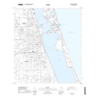
2018 Map of Fort Pierce
USGS Topo · Published 2018About this map
St. Lucie Village and the core of Fort Pierce occupy a high-density coastal corridor defined by the Florida East Coast Railway and the winding Indian River Lagoon. This modern survey illustrates a landscape of established residential neighborhoods like Sunland Gardens and Glidden Park, interspersed with legacy sites such as the Fort Pierce Cem and Pine Grove Cem. The geography is dominated by the complex waterways of the Treasure Coast, where the Intracoastal Waterway cuts through the lagoon toward the Fort Pierce Inlet Entrance Range. To the east, North Hutchinson Island and Hutchinson Island separate the lagoon from the Atlantic Ocean, showing a pattern of coastal development and preserved areas like Jack Island and The Savannahs. Inland, the drainage network includes the Belcher Canal and Tenmile Creek, highlighting the region's managed hydrology.
Find a feature on this map
62 named features on this map. Tap any name to fly to it.
Don’t see what you’re looking for? This feature index may not catch every label — zoom into the map to look around manually.
Map Details
Editions of this 2018 Fort Pierce Map
This is the sole edition of this map. No revisions or reprints were ever made.
Other maps of this area

1948 · Ankona
USGS Topo · 1:24,000

1948 · Eden
USGS Topo · 1:24,000

1948 · Indrio
USGS Topo · 1:24,000

1949 · Fort Pierce
USGS Topo · 1:24,000

1949 · Oslo
USGS Topo · 1:24,000

1949 · Fort Pierce NW
USGS Topo · 1:24,000

1950 · Ankona
USGS Topo · 1:24,000

1950 · Fort Pierce
USGS Topo · 1:24,000

1950 · Fort Pierce NW
USGS Topo · 1:24,000

1950 · Oslo
USGS Topo · 1:24,000