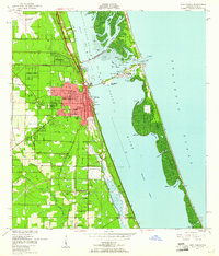
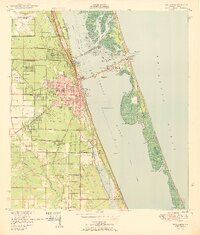
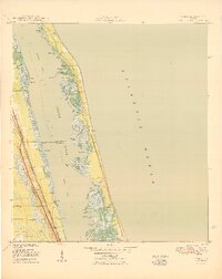
1950 Map of Fort Pierce NW
USGS Topo · Published 1950About this map
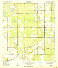
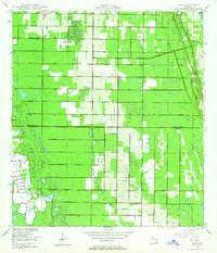
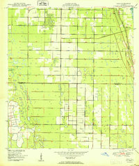
Tenmile Creek winds through the southern landscape of this mid-century Florida interior, which was undergoing significant aeronautic and agricultural development. The United States Coast and Geodetic Survey records a region defined by its drainage patterns and new infrastructure, specifically the St Lucie County Airport in the northeast and smaller aviation sites like the Private Landing Field and Private Airport. The presence of the Florida East Coast rail line and established thoroughfares such as Orange Ave and Kings Highway indicates a growing logistical network supporting the citrus and ranching country. Surveyed shortly after World War II, the map also captures specific survey markers like Monument B (E) and Monument H (E), which were essential for defining property lines and township boundaries in the flat, watery terrain typical of the region before modern drainage projects.
Find a feature on this map
12 named features on this map. Tap any name to fly to it.
Don’t see what you’re looking for? This feature index may not catch every label — zoom into the map to look around manually.
Map Details
Editions of this 1950 Fort Pierce NW Map
2 editions found
Other maps of this area
1948 · Ankona
USGS Topo · 1:24,000
1948 · Indrio
USGS Topo · 1:24,000
1949 · Fort Pierce
USGS Topo · 1:24,000
1949 · Oslo
USGS Topo · 1:24,000

1949 · Fort Pierce NW
USGS Topo · 1:24,000

1950 · Ankona
USGS Topo · 1:24,000
1950 · Fort Pierce
USGS Topo · 1:24,000
1950 · Oslo
USGS Topo · 1:24,000
1950 · Indrio
USGS Topo · 1:24,000
1953 · Okeechobee 1 SE
USGS Topo · 1:24,000
Featured Places
- Saint Lucie County, FL
- United States
- Florida
- Fort Pierce, Saint Lucie County
- Chupco's Landing, Saint Lucie County