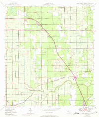
1950 Map of Fort Pierce NW
USGS Topo · Published 1972About this map
Agricultural drainage and early aviation infrastructure define this portion of St. Lucie Co. during a period of transition. The landscape is dominated by the geometric grid of irrigation canals and citrus groves, anchored by the Belcher Canal and the winding course of Tenmile Creek. The 1970 photorevisions highlight the introduction of Floridas Turnpike, which cuts diagonally across the established survey sections and local thoroughfares like Orange Ave and Kings Highway. Several small aviation sites, including a Private Landing Field and Landing Strip, appear alongside the primary St Lucie County Airport, reflecting the region's historical reliance on aerial crop dusting and private flight for managing the expansive groves that characterize this coastal Florida interior.
Find a feature on this map
13 named features on this map. Tap any name to fly to it.
Don’t see what you’re looking for? This feature index may not catch every label — zoom into the map to look around manually.
Map Details
Editions of this 1950 Fort Pierce NW Map
2 editions found
Other maps of this area

1948 · Ankona
USGS Topo · 1:24,000

1948 · Indrio
USGS Topo · 1:24,000

1949 · Fort Pierce
USGS Topo · 1:24,000

1949 · Oslo
USGS Topo · 1:24,000

1949 · Fort Pierce NW
USGS Topo · 1:24,000

1950 · Ankona
USGS Topo · 1:24,000

1950 · Fort Pierce
USGS Topo · 1:24,000

1950 · Fort Pierce NW
USGS Topo · 1:24,000

1950 · Oslo
USGS Topo · 1:24,000

1950 · Indrio
USGS Topo · 1:24,000