
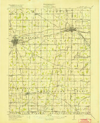
1918 Map of Fort Recovery
USGS Topo · Published 1922About this map
The Greenville Treaty Line cuts diagonally across this landscape, serving as a historic anchor for the settlement of Fort Recovery. This village, situated along the Wabash River, developed as a regional hub where the Lake Erie and Western railroad intersected with local commerce. The surrounding townships of Recovery, Gibson, and Mississinawa are defined by a dense network of rural infrastructure, including a notable concentration of neighborhood schools such as College Hill School and Heinz School. To the north and south, small communities like Macedon and Monterey are linked by established routes like Willshire Road and Celina Road. The map also captures the headwaters of the Mississinewa River in the southern portion, illustrating a terrain transition marked by family-named schools like Harney School and Tobin School that once supported these farming communities.
Find a feature on this map
38 named features on this map. Tap any name to fly to it.
Don’t see what you’re looking for? This feature index may not catch every label — zoom into the map to look around manually.
Map Details
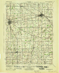
Editions of this 1918 Fort Recovery Map
This is the sole edition of this map. No revisions or reprints were ever made.
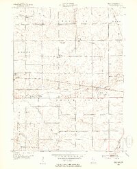
Other maps of this area

1908 · St. Henry
USGS Topo · 1:62,500

1911 · Berne
USGS Topo · 1:48,000

1914 · Celina
USGS Topo · 1:62,500

1915 · Fort Recovery
USGS Topo · 1:48,000

1916 · Winchester
USGS Topo · 1:48,000
1918 · Winchester
USGS Topo · 1:62,500
1943 · Winchester
USGS Topo · 1:62,500

1944 · Celina
USGS Topo · 1:62,500
1952 · Maxville
USGS Topo · 1:24,000

1953 · Muncie
USGS Topo · 1:250,000