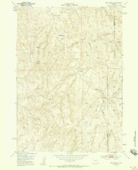
1953 Map of Fort Reno SE
USGS Topo · Published 1958About this map
Drew Ranch anchors this high-plains landscape along the boundary between Johnson and Campbell counties. The area's reliance on water infrastructure is evident through a series of named artesian sources, including First Well, Middle Well, and Drew Well. This collaborative survey between the USGS and the United States Atomic Energy Commission highlights the arid terrain where local drainage systems like Willow Creek and Heldt Draw carve through the earth. Prominent landmarks such as Table Mountain and the high point at VABM Coates provide essential orientation in this cattle-ranching territory. A Diversion Dam at the north end of the map suggests early attempts to manage the seasonal flow of Willow Creek for agricultural or livestock use during the early 1950s.
Find a feature on this map
12 named features on this map. Tap any name to fly to it.
Don’t see what you’re looking for? This feature index may not catch every label — zoom into the map to look around manually.
Map Details
Editions of this 1953 Fort Reno SE Map
4 editions found
Other maps of this area

1953 · Hoe Ranch
USGS Topo · 1:24,000

1953 · Dry Fork Ranch
USGS Topo · 1:24,000

1953 · Fort Reno
USGS Topo · 1:24,000

1953 · Fort Reno SE
USGS Topo · 1:24,000

1953 · Fats Draw
USGS Topo · 1:24,000

1953 · The Nipple
USGS Topo · 1:24,000

1953 · Rolling Pin Ranch
USGS Topo · 1:24,000

1953 · North Butte
USGS Topo · 1:24,000

1954 · House Creek
USGS Topo · 1:24,000

1955 · Newcastle
USGS Topo · 1:250,000