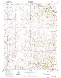
1955 Map of Fort Riley NE
USGS Topo · Published 1978About this map
The Fort Riley Military Reservation dominates the southern landscape of this mid-century survey, where the rolling uplands are dissected by numerous drainage systems. Flowing through the terrain are watercourses like Little Arkansas Creek, Sevenmile Creek, and Threemile Creek, which define the topography between the townships of Madison and Ogden. The map reveals a transition from the structured military training grounds to the surrounding rural sections of Riley and Geary Counties. Local infrastructure is anchored by institutions such as Magic School and the Vinton School, reflecting the educational needs of the area's farming families. Transport is facilitated by the Chicago Rock Island and Pacific railroad and early thoroughfares like Governor Harvey Road. For genealogists, the inclusion of Shanks Cem and Vinton Cem provides essential locations for tracing family roots in this specific Kansas corridor during the 1950s.
Find a feature on this map
24 named features on this map. Tap any name to fly to it.
Don’t see what you’re looking for? This feature index may not catch every label — zoom into the map to look around manually.
Map Details
Editions of this 1955 Fort Riley NE Map
3 editions found

Other maps of this area

1886 · Junction City
USGS Topo · 1:125,000

1889 · Junction City
USGS Topo · 1:125,000

1894 · Junction City
USGS Topo · 1:125,000

1947 · Manhattan
USGS Topo · 1:62,500

1947 · Fort Riley
USGS Topo · 1:62,500

1950 · Keats
USGS Topo · 1:24,000

1950 · Junction City
USGS Topo · 1:24,000

1950 · Alida
USGS Topo · 1:24,000

1951 · Ogden
USGS Topo · 1:24,000

1951 · Wind Creek
USGS Topo · 1:24,000