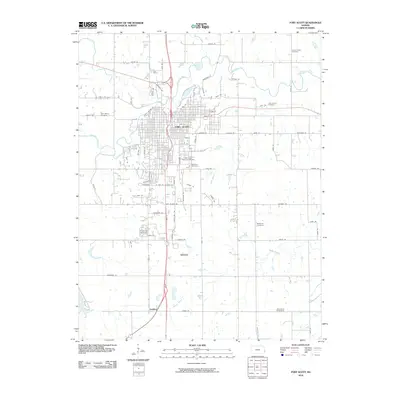
2010 Map of Fort Scott
USGS Topo · Published 2010About this map
The Marmaton River winds across this Bourbon County landscape, framing the city of Fort Scott as it appeared in the early 21st century. The map is a significant resource for genealogists, documenting numerous burial grounds such as the Fort Scott National Cemetery, Saint Marys Cemetery, and Evergreen Cemetery. Beyond the urban center, the survey tracks the southward progression of transit corridors through small settlements like Edward and Godfrey. The grid of rural roads, including Noble Rd and Indian Rd, delineates the agricultural character of the surrounding plains. Tributaries like Wolverine Creek and Lath Branch break the geometric regularity of the land, providing natural landmarks among the farmsteads and historic family cemeteries like Mayberry Cemetery and Clarksburg Cemetery.
Find a feature on this map
53 named features on this map. Tap any name to fly to it.
Don’t see what you’re looking for? This feature index may not catch every label — zoom into the map to look around manually.
Map Details
Editions of this 2010 Fort Scott Map
This is the sole edition of this map. No revisions or reprints were ever made.
Other maps of this area

1884 · Fort Scott
USGS Topo · 1:125,000

1886 · Fort Scott
USGS Topo · 1:125,000

1893 · Fort Scott
USGS Topo · 1:125,000

1939 · Deerfield
USGS Topo · 1:24,000

1942 · Richards
USGS Topo · 1:24,000

1942 · Deerfield
USGS Topo · 1:24,000

1947 · Joplin
USGS Topo · 1:250,000

1948 · Mulberry
USGS Topo · 1:62,500

1948 · Girard
USGS Topo · 1:62,500
1948 · Garland
USGS Topo · 1:24,000