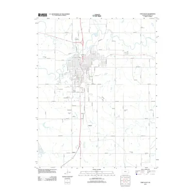
2012 Map of Fort Scott
USGS Topo · Published 2012About this map
Edward serves as a small point of reference within this Bourbon County landscape, reflecting the rural character of southeastern Kansas. The terrain is defined by the winding course of Mill Cr, which cuts through the agricultural lands west of the more developed areas. This survey provides a clear view of the regional drainage and road network as it existed in the early 21st century, showing how local waterways like Mill Cr have influenced the placement of early settlements and transportation routes. The map records the quiet transition of land use in this part of the state, where small, named localities such as Edward persist even as regional population patterns shift toward larger urban centers.
Find a feature on this map
2 named features on this map. Tap any name to fly to it.
Don’t see what you’re looking for? This feature index may not catch every label — zoom into the map to look around manually.
Map Details
Editions of this 2012 Fort Scott Map
This is the sole edition of this map. No revisions or reprints were ever made.
Other maps of this area

1884 · Fort Scott
USGS Topo · 1:125,000

1886 · Fort Scott
USGS Topo · 1:125,000

1893 · Fort Scott
USGS Topo · 1:125,000

1939 · Deerfield
USGS Topo · 1:24,000

1942 · Richards
USGS Topo · 1:24,000

1942 · Deerfield
USGS Topo · 1:24,000

1947 · Joplin
USGS Topo · 1:250,000

1948 · Mulberry
USGS Topo · 1:62,500

1948 · Girard
USGS Topo · 1:62,500
1948 · Garland
USGS Topo · 1:24,000