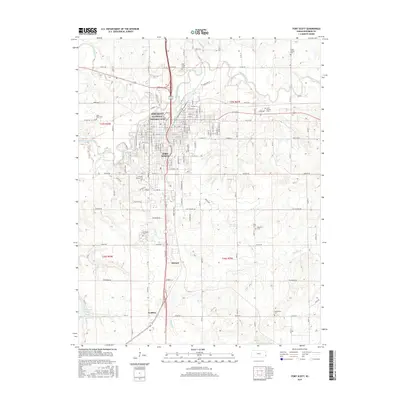
2015 Map of Fort Scott
USGS Topo · Published 2015About this map
Fort Scott serves as the focal point of this Eastern Kansas landscape, where the confluence of military history and agricultural development is clearly visible. The preservation of the Fort Scott National Historic Site near the Marmaton River anchors the downtown grid, which is surrounded by small communities like Edward and Godfrey. The map details a dense network of local cemeteries, such as Saint Marys Cem and Oak Grove Cem, providing valuable location data for genealogical research in Bourbon County. To the south, Lake Fort Scott and Wolverine Cr break the pattern of section-line roads like Indian Rd and Hackberry Rd. The presence of the Ft Scott Community Coll indicates the area's continued role as a regional educational and civic center.
Find a feature on this map
68 named features on this map. Tap any name to fly to it.
Don’t see what you’re looking for? This feature index may not catch every label — zoom into the map to look around manually.
Map Details
Editions of this 2015 Fort Scott Map
This is the sole edition of this map. No revisions or reprints were ever made.
Other maps of this area

1884 · Fort Scott
USGS Topo · 1:125,000

1886 · Fort Scott
USGS Topo · 1:125,000

1893 · Fort Scott
USGS Topo · 1:125,000

1939 · Deerfield
USGS Topo · 1:24,000

1942 · Richards
USGS Topo · 1:24,000

1942 · Deerfield
USGS Topo · 1:24,000

1947 · Joplin
USGS Topo · 1:250,000

1948 · Mulberry
USGS Topo · 1:62,500

1948 · Girard
USGS Topo · 1:62,500
1948 · Garland
USGS Topo · 1:24,000