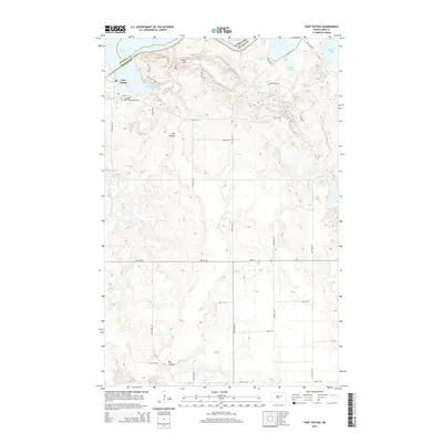
2014 Map of Fort Totten
USGS Topo · Published 2014About this map
Fort Totten anchors this survey of the shoreline where the Ramsey and Benson county lines meet along the southern reaches of Devils Lake. The landscape is defined by the prominent elevation of Sullys Hill, which overlooks a cluster of smaller water bodies including Sweetwater Lake, Court Lake, and Mallard Lake. This 2014 mapping reflects the modern infrastructure of the Wood Lake District, notably the presence of the Cankdeska Cikana Community College and the recreational pathways of the Sullys Hill Nature Trail. A grid of section roads, such as 77th Ave NE and 35th St NE, bisects the area, while the meandering path of the Big Coulee provides a natural break in the terrain to the south and west.
Find a feature on this map
29 named features on this map. Tap any name to fly to it.
Don’t see what you’re looking for? This feature index may not catch every label — zoom into the map to look around manually.
Map Details
Editions of this 2014 Fort Totten Map
This is the sole edition of this map. No revisions or reprints were ever made.
Other maps of this area

1928 · Tokio
USGS Topo · 1:62,500

1931 · Oberon
USGS Topo · 1:62,500

1931 · Tokio
USGS Topo · 1:62,500

1931 · Devils Lake
USGS Topo · 1:62,500

1932 · Grahams Island
USGS Topo · 1:62,500

1950 · Sheyenne
USGS Topo · 1:24,000
1950 · Tokio SW
USGS Topo · 1:24,000

1950 · Tokio
USGS Topo · 1:24,000

1950 · Grahams Island
USGS Topo · 1:62,500

1950 · Devils Lake
USGS Topo · 1:62,500
Featured Places
- Wood Lake District, ND
- St. Michael District, ND
- Fort Totten District, ND
- Fort Totten, Fort Totten District
- Benson County, ND