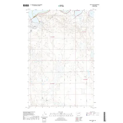
2018 Map of Fort Totten
USGS Topo · Published 2018About this map
Fort Totten and its surrounding glacial landscape define this 2018 survey on the southern shores of Devils Lake. The map details the institutional and historical heart of the area, featuring the Cankdeska Cikana Community Coll and the nearby Fort Totten Post Cem. North of the settlement, the terrain rises toward Sullys Hill, where the Sullys Hill Nature Trail winds through the elevated landscape overlooking Sweetwater Lake. The geography is characterized by numerous prairie potholes and small lakes, including Court Lake and Mallard Lake, connected by a network of rural routes such as Bouret Rd and Fort Totten Rd. In the southern portion of the quadrangle, the drainage of Big Coulee illustrates the subtle hydrological patterns of the northern plains, while Mission Bay marks the eastern reach of the lakeshore.
Find a feature on this map
37 named features on this map. Tap any name to fly to it.
Don’t see what you’re looking for? This feature index may not catch every label — zoom into the map to look around manually.
Map Details
Editions of this 2018 Fort Totten Map
This is the sole edition of this map. No revisions or reprints were ever made.
Other maps of this area

1928 · Tokio
USGS Topo · 1:62,500

1931 · Oberon
USGS Topo · 1:62,500

1931 · Tokio
USGS Topo · 1:62,500

1931 · Devils Lake
USGS Topo · 1:62,500

1932 · Grahams Island
USGS Topo · 1:62,500

1950 · Sheyenne
USGS Topo · 1:24,000
1950 · Tokio SW
USGS Topo · 1:24,000

1950 · Tokio
USGS Topo · 1:24,000

1950 · Grahams Island
USGS Topo · 1:62,500

1950 · Devils Lake
USGS Topo · 1:62,500
Featured Places
- Wood Lake District, ND
- St. Michael District, ND
- Fort Totten District, ND
- Fort Totten, Fort Totten District
- Benson County, ND