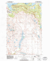
1994 Map of Fort Totten
USGS Topo · Published 1995About this map
Fort Totten and the Fort Totten Indian Agency serve as the primary anchors of this mid-1990s survey, situated along the southern shores of Devils Lake. The landscape is defined by the complex topography of Sullys Hill and its surrounding Sullys Hill National Game Preserve, where elevation shifts dramatically near the Grand Harbor inlet. Much of the southern portion of the quadrangle lies within the Sioux Indian Reservation, showing a mosaic of wetlands and small water bodies such as Sweetwater Lake and Court Lake. Cultural landmarks like Little Hoop Community College and an extensive Old Military Reservation Boundary reflect the area's long history as both a military outpost and a center for tribal administration. The map also identifies modern infrastructure like a Trailer Park and several Gravel Pits amidst the conservation lands of the National Waterfowl Production Area.
Find a feature on this map
24 named features on this map. Tap any name to fly to it.
Don’t see what you’re looking for? This feature index may not catch every label — zoom into the map to look around manually.
Map Details
Editions of this 1994 Fort Totten Map
This is the sole edition of this map. No revisions or reprints were ever made.
Other maps of this area

1928 · Tokio
USGS Topo · 1:62,500

1931 · Oberon
USGS Topo · 1:62,500

1931 · Tokio
USGS Topo · 1:62,500

1931 · Devils Lake
USGS Topo · 1:62,500

1932 · Grahams Island
USGS Topo · 1:62,500

1950 · Sheyenne
USGS Topo · 1:24,000
1950 · Tokio SW
USGS Topo · 1:24,000

1950 · Tokio
USGS Topo · 1:24,000

1950 · Grahams Island
USGS Topo · 1:62,500

1950 · Devils Lake
USGS Topo · 1:62,500
Featured Places
- Wood Lake District, ND
- St. Michael District, ND
- Fort Totten District, ND
- Fort Totten, Fort Totten District
- Ramsey County, ND