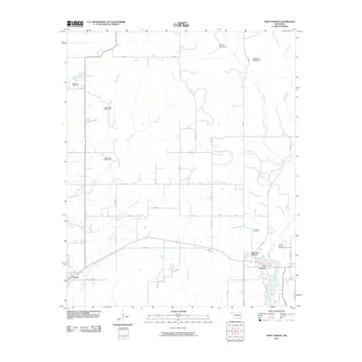
2010 Map of Fort Towson
USGS Topo · Published 2010About this map
Fort Towson and its immediate surroundings are defined by a complex network of named watercourses and local history sites in Choctaw County. This 2010 survey details the geographic layout of the area near the eastern bend of Rock Creek, where the settlements of West Fort Towson and Sawyer are linked by regional roads. A significant concentration of historical interest is found on the eastern side of the map, particularly the Old Fort Towson Cemetery and the primary Fort Towson Cemetery, which serve as critical landmarks for genealogical research.
Find a feature on this map
40 named features on this map. Tap any name to fly to it.
Don’t see what you’re looking for? This feature index may not catch every label — zoom into the map to look around manually.
Map Details
Editions of this 2010 Fort Towson Map
This is the sole edition of this map. No revisions or reprints were ever made.
Other maps of this area

1901 · Alikchi
USGS Topo · 1:125,000

1950 · Mcalester
USGS Topo · 1:250,000

1951 · Frogville
USGS Topo · 1:24,000

1951 · Shoals
USGS Topo · 1:24,000

1951 · Kiomatia
USGS Topo · 1:24,000

1953 · Texarkana
USGS Topo · 1:250,000

1956 · Texarkana
USGS Topo · 1:250,000

1962 · McAlester
USGS Topo · 1:250,000

1962 · Sobol
USGS Topo · 1:24,000
1962 · Swink
USGS Topo · 1:24,000