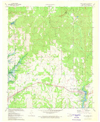
1971 Map of Fort Towson
USGS Topo · Published 1973About this map
Ruins Old Fort Towson Historic Site stands as a focal point in this 1970s survey, marking the location of the frontier outpost near the modern community of Fort Towson. The landscape is defined by the proximity of significant water bodies, including Hugo Lake to the west and Lake Raymond Gary to the south. This era shows the region in transition, with blue hatching indicating areas to be submerged by the reservoir, illustrating the impact of federal water projects on the local geography. The St Louis - San Francisco railroad corridor serves as the primary transportation axis, connecting the settlements of Sawyer and West Fort Towson. Local heritage is preserved in several burial grounds, such as the Old Fort Towson Cemetery and Fort Towson Cemetery, while the Box Springs Church highlights the rural social structure within the Wilson township area.
Find a feature on this map
26 named features on this map. Tap any name to fly to it.
Don’t see what you’re looking for? This feature index may not catch every label — zoom into the map to look around manually.
Map Details
Editions of this 1971 Fort Towson Map
This is the sole edition of this map. No revisions or reprints were ever made.
Other maps of this area

1901 · Alikchi
USGS Topo · 1:125,000

1950 · Mcalester
USGS Topo · 1:250,000

1951 · Frogville
USGS Topo · 1:24,000

1951 · Shoals
USGS Topo · 1:24,000

1951 · Kiomatia
USGS Topo · 1:24,000

1953 · Texarkana
USGS Topo · 1:250,000

1956 · Texarkana
USGS Topo · 1:250,000

1962 · McAlester
USGS Topo · 1:250,000

1962 · Sobol
USGS Topo · 1:24,000
1962 · Swink
USGS Topo · 1:24,000