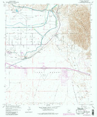
1965 Map of Fortuna
USGS Topo · Published 1979About this map
The Gila River corridor east of Yuma Mesa is marked by a complex system of irrigation and historic transportation routes during this late 1970s revision. At the edge of the North Gila Valley, the Redondo Ruins (Butterfield Stage Sta) preserve a connection to mid-19th-century overland travel, while the Southern Pacific tracks and numerous Gaging Stations follow the water's path toward Blaisdell. The landscape is sharply divided between the agricultural river bottoms and the arid Yuma Desert to the south, where the Yuma No 1 Airfield and expansive military tracts like the Luke Air Force Range dominate the terrain. A notable inclusion is the Camino Del Diablo (Approximate West Route), tracing an ancient and treacherous desert path through the foothills of the Gila Mountains. Modern expansion is evident at Arizona Western College and the growing Foothills Country Club.
Find a feature on this map
36 named features on this map. Tap any name to fly to it.
Don’t see what you’re looking for? This feature index may not catch every label — zoom into the map to look around manually.
Map Details
Editions of this 1965 Fortuna Map
4 editions found
Other maps of this area

1903 · Yuma
USGS Topo · 1:125,000

1905 · Yuma
USGS Topo · 1:125,000

1926 · Fortuna
USGS Topo · 1:62,500

1929 · Fortuna
USGS Topo · 1:62,500

1929 · Laguna
USGS Topo · 1:62,500

1940 · Yuma
USGS Topo · 1:62,500

1942 · Yuma
USGS Topo · 1:250,000

1943 · Laguna
USGS Topo · 1:62,500

1945 · Picacho Peak
USGS Topo · 1:62,500

1945 · Yuma
USGS Topo · 1:62,500