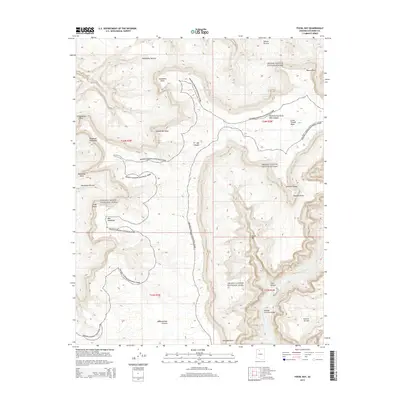
2014 Map of Fossil Bay
USGS Topo · Published 2014About this map
Grand Canyon National Park terrain dominates this 2014 survey, illustrating the complex vertical geography of the south rim and the inner canyon floor. The Colorado River carves through the southeast corner of the map, creating the Middle Granite Gorge and the turbulent Fossil Rapids. The landscape is defined by massive plateau features and stepped landforms, including the prominent Great Thumb Mesa and expansive benches like Gatagama Terrace and Alarcon Terrace. Deep incisions into the canyon walls are marked by Specter Chasm, Olo Canyon, and the winding Matkatamiba Canyon. Strategic overlooks and high points such as Enfilade Point, Stanton Point, and Tahuta Point provide topographical reference for this uninhabited wilderness area. The survey clearly delineates the park boundaries and the township grid, specifically highlighting the intersection of sections within T34N and T33N.
Find a feature on this map
29 named features on this map. Tap any name to fly to it.
Don’t see what you’re looking for? This feature index may not catch every label — zoom into the map to look around manually.
Map Details
Editions of this 2014 Fossil Bay Map
This is the sole edition of this map. No revisions or reprints were ever made.
Other maps of this area

1886 · Kaibab
USGS Topo · 1:250,000

1953 · Grand Canyon
USGS Topo · 1:250,000

1957 · Grand Canyon
USGS Topo · 1:250,000

1958 · Grand Canyon
USGS Topo · 1:250,000

1960 · Grand Canyon
USGS Topo · 1:250,000

1962 · Kanab Point
USGS Topo · 1:62,500

1962 · Havasupai Point
USGS Topo · 1:62,500
1962 · Powell Plateau
USGS Topo · 1:62,500

1962 · Supai
USGS Topo · 1:62,500

1984 · Grand Canyon
USGS Topo · 1:100,000