
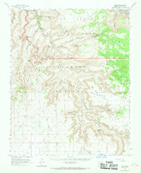
1962 Map of Supai
USGS Topo · Published 1964About this map
Supai sits at the heart of this early 1960s survey, illustrating the isolated geography of the Havasupai Indian Reservation. The settlement is defined by the flow of Cataract Creek as it feeds famous water features like Havasu Falls, Navajo Falls, and the life-giving Havasu Springs. The landscape is a complex network of named points and canyons, from Watahomigi Point to the deep recesses of Carbonate Canyon and Havatagvitch Canyon.
Find a feature on this map
76 named features on this map. Tap any name to fly to it.
Don’t see what you’re looking for? This feature index may not catch every label — zoom into the map to look around manually.
Map Details
Editions of this 1962 Supai Map
2 editions found
Other maps of this area

1886 · Chino
USGS Topo · 1:250,000

1886 · Kaibab
USGS Topo · 1:250,000

1891 · Chino
USGS Topo · 1:250,000

1948 · Williams
USGS Topo · 1:250,000

1953 · Grand Canyon
USGS Topo · 1:250,000

1954 · Williams
USGS Topo · 1:250,000

1956 · Williams
USGS Topo · 1:250,000

1957 · Grand Canyon
USGS Topo · 1:250,000

1958 · Grand Canyon
USGS Topo · 1:250,000

1960 · Williams
USGS Topo · 1:250,000