
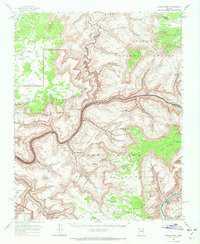
1962 Map of Kanab Point
USGS Topo · Published 1964About this map
Havasupai Indian Reservation occupies the southwestern corner of this 1962 survey, where the turquoise waters of Havasu Creek drop through legendary cataracts including Havasu Falls, Mooney Falls, and Beaver Falls. The landscape is dominated by the massive erosional depth of the Colorado River corridor as it winds between the Kanab Plateau and Coconino Plateau. This era of mapping shows the river in its natural state before major flow regulation, featuring treacherous whitewater sections like Kanab Rapids, Upset Rapids, and Sinyala Rapids. Notable landmarks such as Keyhole Natural Bridge and the massive Mount Sinyala Mesa stand above the deep drainage of Sinyala Canyon. Cultural features are sparse in this wilderness, though a Cem and a Mine appear near the Havasu Creek settlements, alongside remote geographic markers like Kanab Point and Shanub Point.
Find a feature on this map
76 named features on this map. Tap any name to fly to it.
Don’t see what you’re looking for? This feature index may not catch every label — zoom into the map to look around manually.
Map Details
Editions of this 1962 Kanab Point Map
2 editions found
Other maps of this area

1886 · Kaibab
USGS Topo · 1:250,000

1953 · Grand Canyon
USGS Topo · 1:250,000

1954 · Heaton Knolls SE
USGS Topo · 1:24,000

1954 · Heaton Knolls
USGS Topo · 1:62,500

1957 · Grand Canyon
USGS Topo · 1:250,000

1957 · Jumpup Canyon
USGS Topo · 1:62,500

1958 · Grand Canyon
USGS Topo · 1:250,000

1958 · Big Springs
USGS Topo · 1:62,500

1960 · Grand Canyon
USGS Topo · 1:250,000

1962 · Tuckup Canyon
USGS Topo · 1:62,500