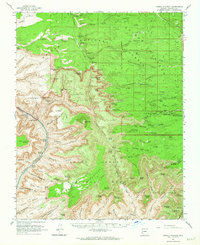
1962 Map of Powell Plateau
USGS Topo · Published 1964About this map
Grand Canyon National Park and the Kaibab National Forest meet in this 1962 survey, revealing the complex verticality of the North Rim. The landscape is dominated by the massive Powell Plateau, which stands isolated between the Tapeats Amphitheater and Shinumo Amphitheater. This era captures the backcountry before modern visitor infrastructure reached many of these points, focusing instead on the hydrological and geological network of the Middle Granite Gorge.
Find a feature on this map
138 named features on this map. Tap any name to fly to it.
Don’t see what you’re looking for? This feature index may not catch every label — zoom into the map to look around manually.
Map Details
Editions of this 1962 Powell Plateau Map
2 editions found
Other maps of this area

1886 · Kaibab
USGS Topo · 1:250,000

1903 · Bright Angel
USGS Topo · 1:48,000

1906 · Bright Angel
USGS Topo · 1:48,000

1936 · Jacobs Lake
USGS Topo · 1:48,000

1940 · Jacob Lake
USGS Topo · 1:62,500

1953 · Jacobs Lake
USGS Topo · 1:62,500

1953 · Grand Canyon
USGS Topo · 1:250,000

1957 · Grand Canyon
USGS Topo · 1:250,000

1957 · Jumpup Canyon
USGS Topo · 1:62,500

1958 · Grand Canyon
USGS Topo · 1:250,000