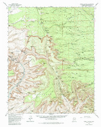
1962 Map of Powell Plateau
USGS Topo · Published 1985About this map
The Colorado River carves through the heart of the Grand Canyon in this early 1960s study, revealing the immense vertical complexity of the Grand Canyon National Park and Kaibab National Forest. The landscape is defined by its massive plateaus and isolated buttes given evocative names such as Holy Grail Temple, Masonic Temple, and King Arthur Castle. These landforms rise above deep drainages like Tapeats Creek and Shinumo Creek, where the river's power is marked by named river miles and hazards including Specter Rapids and Hundred and Thirtyfive Mile Rapids.
Find a feature on this map
123 named features on this map. Tap any name to fly to it.
Don’t see what you’re looking for? This feature index may not catch every label — zoom into the map to look around manually.
Map Details
Editions of this 1962 Powell Plateau Map
2 editions found
Other maps of this area

1886 · Kaibab
USGS Topo · 1:250,000

1903 · Bright Angel
USGS Topo · 1:48,000

1906 · Bright Angel
USGS Topo · 1:48,000

1936 · Jacobs Lake
USGS Topo · 1:48,000

1940 · Jacob Lake
USGS Topo · 1:62,500

1953 · Jacobs Lake
USGS Topo · 1:62,500

1953 · Grand Canyon
USGS Topo · 1:250,000

1957 · Grand Canyon
USGS Topo · 1:250,000

1957 · Jumpup Canyon
USGS Topo · 1:62,500

1958 · Grand Canyon
USGS Topo · 1:250,000