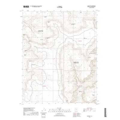
2018 Map of Fossil Bay
USGS Topo · Published 2018About this map
Grand Canyon National Park encompasses this entire stretch of the Arizona rim and river corridor, where the Colorado River carves through the Middle Granite Gorge. The landscape is defined by massive limestone and sandstone formations, including Great Thumb Mesa and the expansive Olo Mesa to the northwest. This 2018 survey reveals the intricate network of drainage systems that feed into the main canyon, such as Hundred and Forty Mile Canyon and Fossil Canyon, which terminates at Fossil Bay.
Find a feature on this map
28 named features on this map. Tap any name to fly to it.
Don’t see what you’re looking for? This feature index may not catch every label — zoom into the map to look around manually.
Map Details
Editions of this 2018 Fossil Bay Map
This is the sole edition of this map. No revisions or reprints were ever made.
Other maps of this area

1886 · Kaibab
USGS Topo · 1:250,000

1953 · Grand Canyon
USGS Topo · 1:250,000

1957 · Grand Canyon
USGS Topo · 1:250,000

1958 · Grand Canyon
USGS Topo · 1:250,000

1960 · Grand Canyon
USGS Topo · 1:250,000

1962 · Kanab Point
USGS Topo · 1:62,500

1962 · Havasupai Point
USGS Topo · 1:62,500
1962 · Powell Plateau
USGS Topo · 1:62,500

1962 · Supai
USGS Topo · 1:62,500

1984 · Grand Canyon
USGS Topo · 1:100,000