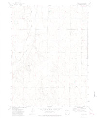
1972 Map of Fosston
USGS Topo · Published 1974About this map
Crow Creek carves a path through this section of the High Plains, where the landscape is defined by the legacy of early transit and ranching. The presence of an Old Railroad Grade running parallel to the creek valley suggests the remnants of former transportation corridors that once linked these rural outposts. The settlement of Fosston and the nearby Hilltop Ranch illustrate the scattered nature of habitation in this arid environment, where water sources like Bidwell Lake and Sand Creek were essential for sustaining life and livestock.
Find a feature on this map
14 named features on this map. Tap any name to fly to it.
Don’t see what you’re looking for? This feature index may not catch every label — zoom into the map to look around manually.
Map Details
Editions of this 1972 Fosston Map
This is the sole edition of this map. No revisions or reprints were ever made.
Other maps of this area

1950 · Greasewood Lake
USGS Topo · 1:24,000

1950 · Barnesville
USGS Topo · 1:24,000

1951 · Point Of Rocks
USGS Topo · 1:24,000

1954 · Greeley
USGS Topo · 1:250,000

1957 · Greeley
USGS Topo · 1:250,000

1958 · Greeley
USGS Topo · 1:250,000

1961 · Greeley
USGS Topo · 1:250,000

1964 · Greeley
USGS Topo · 1:250,000

1965 · Greeley
USGS Topo · 1:250,000

1972 · Dutch Girl Lake
USGS Topo · 1:24,000