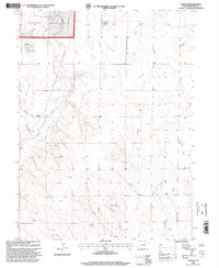
1997 Map of Fosston
USGS Topo · Published 2000About this map
Pawnee National Grassland dominates the northern corner of this landscape, where the high plains terrain is defined by the seasonal drainage of Crow Creek and Sand Creek. The small settlement of Fosston sits near the western edge, serving as a focal point for the surrounding ranching and agricultural operations. The map reflects a rural economy dependent on water management and storage, illustrated by the network of ditches, a Water Tank, and isolated Storage Bins scattered across the township and range lines.
Find a feature on this map
14 named features on this map. Tap any name to fly to it.
Don’t see what you’re looking for? This feature index may not catch every label — zoom into the map to look around manually.
Map Details
Editions of this 1997 Fosston Map
This is the sole edition of this map. No revisions or reprints were ever made.
Other maps of this area

1950 · Greasewood Lake
USGS Topo · 1:24,000

1950 · Barnesville
USGS Topo · 1:24,000

1951 · Point Of Rocks
USGS Topo · 1:24,000

1954 · Greeley
USGS Topo · 1:250,000

1957 · Greeley
USGS Topo · 1:250,000

1958 · Greeley
USGS Topo · 1:250,000

1961 · Greeley
USGS Topo · 1:250,000

1964 · Greeley
USGS Topo · 1:250,000

1965 · Greeley
USGS Topo · 1:250,000

1972 · Dutch Girl Lake
USGS Topo · 1:24,000