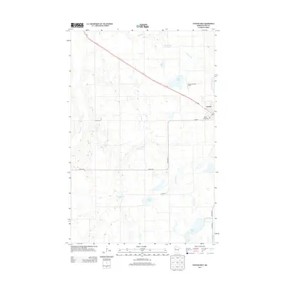
2013 Map of Fosston West
USGS Topo · Published 2013About this map
The Fosston area in Polk County is defined by a dense network of glacial lakes and prairie waterways that shape the landscape of northern Minnesota. This 2013 survey details the western approach to the city, where Us-2 serves as the primary corridor across a terrain of agricultural fields and wetland depressions. Smaller water bodies like Strand Lake, Ouff Lake, and Homme Lake are interspersed throughout the township, while the Sand Hill River and Poplar River provide natural drainage across the quadrangle. For those researching local heritage, the map identifies specific landmarks such as Landsverk Cem and Hansville Cem, alongside public facilities like the Fosston Municipal Airport and the City of Fosston Campground. The placement of these rural cemeteries and lake-bound settlements illustrates the 21st-century footprint of this long-established farming community.
Find a feature on this map
21 named features on this map. Tap any name to fly to it.
Don’t see what you’re looking for? This feature index may not catch every label — zoom into the map to look around manually.
Map Details
Editions of this 2013 Fosston West Map
This is the sole edition of this map. No revisions or reprints were ever made.
Other maps of this area

1919 · Fosston
USGS Topo · 1:62,500

1954 · Bemidji
USGS Topo · 1:250,000

1957 · Bemidji
USGS Topo · 1:250,000

1958 · Bemidji
USGS Topo · 1:250,000

1969 · Olga
USGS Topo · 1:24,000

1969 · Mc Intosh NE
USGS Topo · 1:24,000

1969 · Fosston East
USGS Topo · 1:24,000
1969 · Mc Intosh
USGS Topo · 1:24,000

1969 · Fosston West
USGS Topo · 1:24,000
1969 · Winger
USGS Topo · 1:24,000